Important Safety Notice: Visiting these remote volcanic areas requires hiring experienced local guides. Due to active volcanic conditions at Reventador, challenging terrain, rapidly changing weather, and the isolated jungle environment, attempting these treks without proper guidance is dangerous and in many cases prohibited. Local guides know current volcanic activity, trail conditions, and emergency protocols—they’re essential for your safety and for having a successful expedition.
Deep in Ecuador’s eastern cloud forests, where the Andes give way to the Amazon basin, two remarkable volcanoes tell very different stories. Reventador—”The Exploder”—lives up to its name with near-constant eruptions, while the isolated Sumaco rises like a sentinel from the rainforest, quietly guarding one of Earth’s most biodiverse ecosystems.
Reventador: The Restless Giant
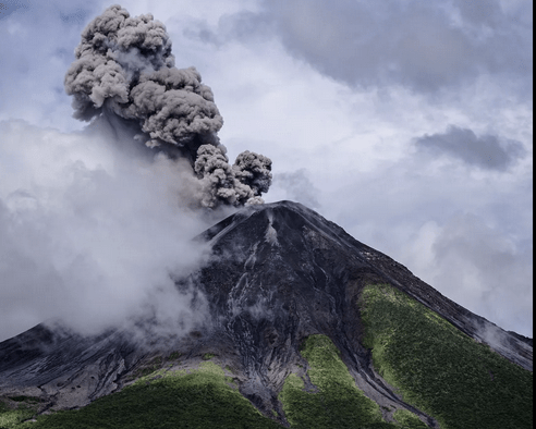
Standing at 3,562 meters (11,686 feet), Reventador is Ecuador’s most temperamental volcano. Since 1541, it has erupted over 25 times, and since July 2008, it has been in a state of continuous activity—a volcanic personality that refuses to quiet down. The volcano sits about 90 kilometers east of Quito, nestled within its namesake national park in a remote stretch of rainforest.
The 2002 eruption remains the largest in Ecuador’s recent history. The eruption column shot 17 kilometers into the sky—visible all the way from Quito—and pyroclastic flows raced up to 8 kilometers down the volcano’s flanks. Over two million people were affected by the ashfall, and Quito’s international airport had to close. Since then, the volcano has been constantly remaking itself, destroying and rebuilding its summit in an endless cycle of creation and destruction.
What makes Reventador particularly fascinating is its location within a 4-kilometer-wide avalanche caldera, the remnant of a massive ancient collapse. The current active cone has grown within this natural amphitheater, rising about 1,300 meters above the caldera floor. Scientists monitoring the volcano have discovered that it operates on an approximately 20-year cycle of destruction and reconstruction, with the summit becoming unstable when it reaches around 3,590-3,600 meters in height.
Sumaco Stratavolcano: The Isolated Sentinel
In stark contrast to its explosive neighbor, Sumaco is a study in tranquility. This nearly perfectly symmetrical stratovolcano rises to 3,990 meters (13,091 feet), standing in splendid isolation about 50 kilometers east of the main Andean volcanic chain. Its last confirmed eruption occurred around 1895—over 130 years ago.
What Sumaco lacks in volcanic drama, it more than makes up for in biodiversity. The volcano harbors more than 6,000 species of vascular plants like ferns, including over 90 endemic species found nowhere else on Earth. The area is home to unique creatures like the Osornophryne sumacoensis toad, only known from Sumaco’s eastern slopes, and the Pristimantis ernesti robber frog, found solely on the summit.
The volcano’s rocks are geologically distinct from typical Andean volcanoes. Instead of the usual andesitic composition, Sumaco features alkaline basanite and phonolitic rocks—evidence of its unique origin in the rear volcanic arc, far from the main subduction zone activity. At its summit sits a broad crater containing a small central cone, a reminder that while Sumaco may be sleeping, it’s not extinct.
Getting There: Your Travel Options
From Quito: The Northern Approach
The Route to Reventador
The most common approach to Reventador begins in Ecuador’s capital, Quito. The journey takes you approximately 100 kilometers east along the winding Quito-Lago Agrio highway, dropping from the high Andes into the cloud forests of the Amazon foothills—a spectacular 3-4 hour drive through dramatically changing landscapes.
By Bus: Buses depart from Quito’s main terminal heading to Lago Agrio, with departures around 7:00 AM. The fare is approximately $10, and the journey takes about 5 hours. You’ll want to ask for “El Reventador” but specify that you want to be dropped at “Hostería El Reventador” near the San Rafael area—not the town of El Reventador itself. Watch for the Rio Salado sign, followed by an obvious pyroclastic flow deposit, and then a large river gorge. Don’t rely solely on the driver’s memory; stay alert as you approach the area.
Important: Bring your passport—you’ll pass through a checkpoint where ID verification is required.
By Private Vehicle: If you’re driving, the journey takes 3-4 hours from Quito along the same highway. This option gives you more flexibility and the ability to stop at viewpoints along the way.
Base Camp: The Hostería El Reventador serves as the primary base for volcano visitors. Located near where San Rafael Falls once stood (the waterfall collapsed in 2020 due to natural riverbed erosion), the hostería offers comfortable rooms for around $12 USD, private bathrooms, a restaurant, and several pools fed by mountain streams. From here, you can arrange guided tours and access trails into the volcano’s caldera. The property also provides excellent viewpoints of the volcano, approximately 10 kilometers away.
Reaching Sumaco from Quito
To reach Sumaco, take a bus from Quito’s Terrestre Terminal to Coca (Francisco de Orellana). Buses depart hourly with companies like Coop. Baños and Amazonas—about a 6-hour journey. Ask to be dropped at “Wawa Sumaco.” From there, you can hire a pickup truck for about $7 USD for the 7.5-kilometer journey to Pacto Sumaco community (or walk for about 45 minutes).
Alternatively, drive the Quito-Baeza-Tena road, then take the Hollin-Loreto-Coca road. About an hour from the junction, you’ll reach Wawa Sumaco, where you take the dirt road left to Pacto Sumaco community.
From Puyo: The Southern Gateway
Understanding the Geography
Puyo sits in Ecuador’s Amazon region, southeast of both Reventador and Sumaco. While not as direct as the Quito route, travelers coming from the Amazon or southern Ecuador may find themselves using Puyo as a staging point.
The Waterfall Route Connection
Between the highland town of Baños and Puyo lies the famous Ruta de las Cascadas (Waterfall Route)—a 60-kilometer stretch of road featuring seven spectacular waterfalls, including the powerful Pailón del Diablo (Devil’s Cauldron). This route doesn’t directly access Reventador, but it’s part of the broader Amazon access network.
Routing to Reventador from Puyo
From Puyo, you would need to:
- Travel north to Baños (approximately 1 hour)
- Continue to Quito (about 3.5-4 hours)
- Then follow the Quito-Lago Agrio route east to Reventador (3-4 hours)
Alternatively, you could route through Tena, heading north toward Archidona and then westward to intercept the Quito-Lago Agrio road, though this involves longer travel on secondary roads.
The Reality: While possible, using Puyo as a starting point to Reventador is significantly less efficient than the direct Quito route. The total journey would likely take 8-10 hours with connections, compared to 3-5 hours from Quito.
For Sumaco: The route from Puyo is more practical. Travel north through Tena, then continue toward Coca, watching for the Wawa Sumaco turnoff—a journey of approximately 4-5 hours.
Planning Your Visit
Best Time to Go
Dry Season (November-March): Offers better visibility and easier trail conditions, though “dry” in the Amazon cloud forest is relative—expect rain regardless.
Wet Season (April-October): Higher rainfall means muddier trails but often more dramatic waterfall displays and lush vegetation.
For volcano viewing, clear mornings offer the best chance to see the peaks before afternoon clouds roll in.
What to Bring
Essential Gear:
- Rubber boots (Wellington boots)—absolutely critical for muddy trails
- Waterproof rain gear and dry bags
- Warm layers (temperatures can drop to 5-10°C at night)
- Sleeping bag (rated for cold, damp conditions)
- Headlamp with extra batteries
- Water purification system
- Sun protection
- Insect repellent
- Camera with protective cover
Safety Considerations
For Reventador:
- Check current volcanic activity with Instituto Geofísico in Quito before departing
- The volcano’s activity level determines where you can safely go
- Always hire a local guide who knows current conditions
- Be prepared for sudden weather changes
- Trails can be steep, slippery, and challenging
For Sumaco:
- The 41-kilometer round-trip trek takes 3-4 days
- Hiring a guide is mandatory (about $38 USD per day)
- Three shelters are available along the route, but bring sleeping gear
- Physical fitness is essential—expect steep, muddy terrain
- The trail passes through six climatic zones with diverse ecosystems
What to Expect
At Reventador: If volcanic activity permits, you might camp within the caldera, about 3-4 kilometers from the active cone—close enough to witness the spectacle of explosions, incandescent lava bombs, and flowing lava at night. The experience is otherworldly: the glow of molten rock reflected in low-hanging clouds, the rumble of explosions echoing through the forest, and the sense of nature’s raw power on full display.
From safer observation points at Hostería El Reventador, you can watch the volcano’s nighttime pyrotechnics from about 10 kilometers away—still dramatic but without the intense hike.
At Sumaco: The journey to Sumaco’s summit is an immersive rainforest experience. You’ll pass through multiple ecosystems, from lowland Amazon forest through cloud forest to the páramo near the summit. The trail follows ridgelines and crosses streams, with shelters positioned at strategic intervals. From the summit, on clear days, you can see the snow-capped peaks of Antisana, Cayambe, and Cotopaxi to the west, the Amazon basin spreading east to the horizon, and the active Reventador volcano in the distance.
Practical Tips
- Book guides in advance through your accommodation or the Pacto Sumaco community organization
- Allow extra time for weather delays and trail conditions
- Respect park regulations—volcanic areas can close without notice for safety
- Travel light but prepared—every kilogram matters on steep, muddy trails
- Stay flexible—cloud forest weather and volcanic activity can change plans quickly
- Consider hot springs—The Termas de Papallacta lies along the return route to Quito and offers perfect post-trek relaxation
The Bigger Picture
These two volcanoes represent different faces of Ecuador’s extraordinary geology. Reventador shows us the planet’s ongoing creation—a mountain literally rebuilding itself before our eyes. Sumaco reminds us that volcanoes aren’t just about fire and fury; they’re also architects of biodiversity, their slopes creating microclimates and isolated ecosystems where unique life forms evolve.
Together, they form part of Ecuador’s eastern volcanic chain, a geological feature that exists far from the main Andean volcanic axis. This rear-arc volcanism results from complex interactions between the subducting Nazca plate and the South American continent, creating a volcanic landscape unlike anywhere else in the Andes.
Whether you’re drawn by the spectacle of an active volcano perpetually reshaping itself or the quiet majesty of a biodiversity hotspot rising from the rainforest, these volcanoes offer something profound: a chance to witness Earth’s creative forces at work, in one of the planet’s most biodiverse regions.
Final Thoughts
Visiting Reventador and Sumaco isn’t for casual tourists—these are serious adventures requiring proper preparation, physical fitness, and respect for nature’s power. But for those willing to make the journey, the rewards are extraordinary. You’ll experience cloud forests few people see, witness geological processes that most only read about, and gain a visceral understanding of the forces that continue to shape our planet.
The journey from either Quito or Puyo may be long and challenging, but standing before these volcanic giants—one erupting in the night, the other cloaked in pristine forest—you’ll understand that some experiences are worth every muddy step of the approach.
Jake is originally from Sydney and co-founded Ecuador Eco Adventure with Wlady back in 2006. Together they built one of the country's most prominent climbing and hiking agency that is number one in summit attempts of Chimborazo, Cotopaxi, Antisana, and Cayambe. Ecuador Eco Adventure has since been recommended in National Geographic Adventure, The Rough Guide, and the Lonely Planet.


0 Comments